Hytech-imaging / Pelagis Observatory UAR 3462 CNRS La Rochelle Université
Digital aerial monitoring solution for birdlife and marine megafauna
Designed to address the challenge of digitally monitoring marine megafauna, Stormm helps advance scientific understanding and meets the environmental requirements associated with offshore wind projects. The solution is based on two complementary components: Stormm-Survey, for acquiring very high-resolution aerial imagery; and Stormm-Analysis, to support expert data analysis.
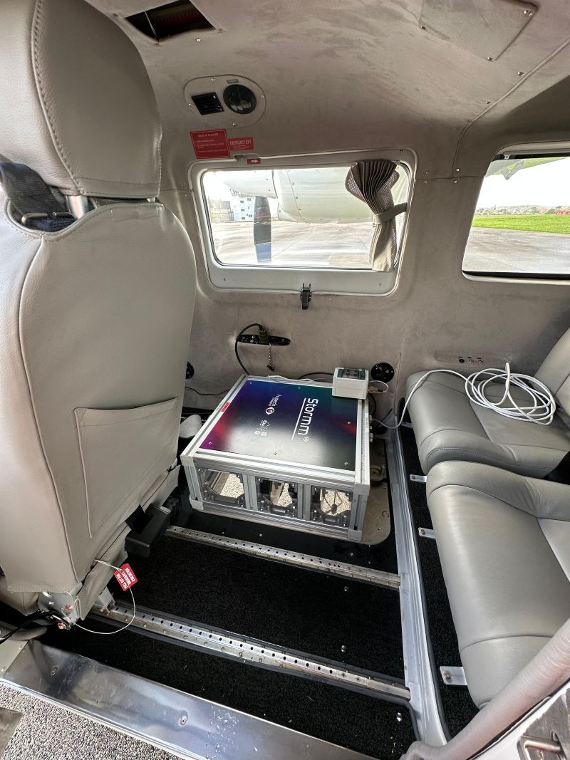
Stormm-Survey utilizes proprietary optical technology, the Stormm® system. Following data acquisition, Stormm-Analysis provides a database of aerial photos ready for expert identification, along with user-friendly and scalable analysis tools.
With Stormm-Survey, get a reliable imaging service that offers:
an optical system designed for environmental monitoring
Precise and wide-swath
Robust to glint conditions at the sea surface
Flexible, with 30-minutes installation on various aircraft models, and use at high or low altitude (with or without observer)
optimal acquisition conditions
Continuous weather monitoring
Complete operations management
On-call team of operators
Reactive set up thanks to the operation of several aircrafts and Stormm® systems
Data traceability
images meeting identification requirements
Precise: spatial resolution < 2 cm
High quality: optics and sensors adapted to identification at sea
High fidelity: image characteristics maintained regardless of flight altitude
Reliable: systematic image quality control
With Stormm-Analysis, benefit from tailor-made identification support, focused on your environmental expertise, including:
time-saving
in identification tasks by providing an image database that incorporates AI-powered automated pre-detection of individuals and objects of interest (target localization and segmentation)
easier identification
using an intuitive tool (image navigation, tagging tool, identification assistance features) that is also scalable (with the option to add custom features)
cost control and interoperability
through a plugin developed for the open-source software QGIS, freeing users from proprietary solutions and ensuring the long-term viability and reusability of data
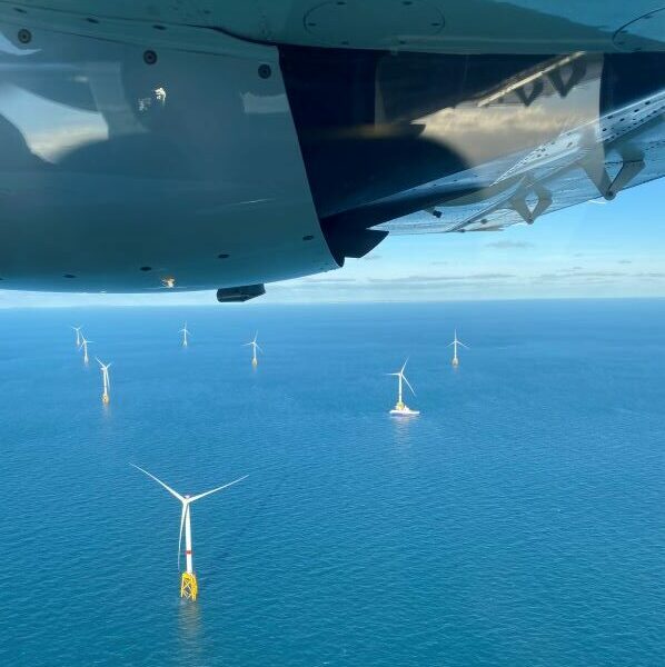
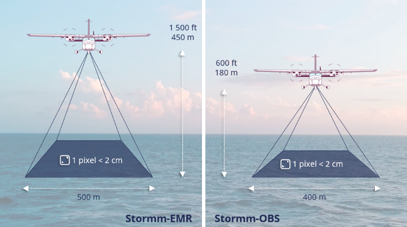
Flexible and high-performance, the Stormm solution adapts to various data collection scenarios, whether at high or low altitudes, with or without on-board observers. It enables the coverage of vast areas in a limited number of flight hours, while ensuring a wide swath width (400 to 500 m) and very high spatial resolution (1 to 2 cm). Stormm meets the specifications of the SAMM Marine Megafauna Aerial Monitoring Protocol.
The optical component of the solution (the Stormm® system) was developed in collaboration with the Pelagis Observatory, which regularly deploys Stormm for national and international reference campaigns (SAMM and SCANS). Stormm also contributes to MIGRATLANE, a national project for monitoring birds in the Northeast Atlantic led by the French Office for Biodiversity, and to the national OWFSOMM project led by France Énergies Marines, dedicated to the intercalibration of monitoring protocols.
References
4600 km
covered in 15 flights for the
SCANS
campaigns in 2022
24 flights
over 4 sites in the frame of the MIGRATLANE project from 2023 to 2026
4 MRE sites
surveyed during 14 sessions for the OWFSOMM project in 2022 and 2023
Partner
Acquisition parameters for high- and low-altitude
configurations and system characteristics
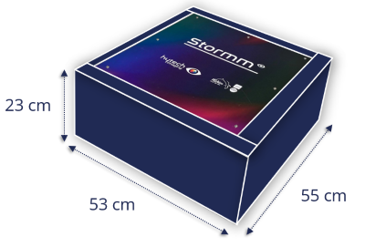
The acquisition parameters (wide swath of 400 to 500 m and very high spatial resolution of 1 to 2 cm) are maintained in both the high-altitude configuration (Stormm-MRE) and the low-altitude configuration (Stormm-OBS with an observer). They are illustrated below. The Stormm® optical system features compact dimensions, a controlled weight (40 kg), and low power consumption, facilitating its rapid installation on various aircraft.
Hytech-imaging / XSun
Low-carbon service for digital monitoring of avifauna and marine megafauna
The deployment of offshore wind farms as a response to the challenges of the energy transition calls for reflection on biodiversity monitoring practices and tools, in order to make them less invasive and less polluting. Solar-Stormm is responding to this challenge by developing a low-carbon, silent version of the Stormm-Survey service.
The service, which is currently being industrialised, is based on the miniaturisation of the Stormm optical system and its integration on a long-endurance solar drone. Hytech-imaging is using the SolarXOne drone developed by its partner XSun.
The long-term aim is to decarbonise, automate and standardise digital surveys to monitor avifauna and marine megafauna
Solar-Stormm
Solar-Stormm has already successfully met the challenge of miniaturisation, while enabling digital surveys comparable to those of the Stormm system
Solar-Stormm offers greater deployment flexibility and autonomy of acquisition (transport in a van, deployment from any open area, autonomous image acquisition according to a pre-defined flight plan)
The next issue to be addressed concerns authorisations to fly beyond 12 nautical miles, the outer limit of territorial waters
Immerse in a Solar-Stormm mission
Take a two-minute behind-the-scenes look at a Solar-Stormm operational test mission.
Prototype Scaling
Following the development of the first prototype in 2024 with support from the OFB, the industrialization of the Solar-Stormm service is continuing through the SDAMM (Decarbonized and Automated Monitoring of Marine Megafauna) project, certified by the Pôle Mer Bretagne Atlantique and supported by Ailes Marines as part of its IBReizh program.
Supports
They talk about Solar-Stormm…
France 3 Région / ICI TV Report Offshore wind power: What impact on biodiversity? – October 2025
Article Le Moniteur – février 2026
Article Mer et Marine – octobre 2025
Article Le Marin – octobre 2025